Discover our cutting-edge geospatial solutions, and designed for precision and versatility, our products deliver unparalleled accuracy and detail, empowering industries like urban planning, engineering, environmental monitoring, and resource management. Elevate your decision-making with reliable data and imagery tailored to meet your project needs!
Sub-meter resolution imagery that delivers clarity and accuracy
High Resolution
Affordable
Our solutions are more cost-efficient than other satellite and non-satellite alternatives
Reliable
Up to 7 daily revisits of any point of interest and frequent remaps of areas of interest
Scalable
We have the collection capacity to meet your demands
Global
Capture any area or point of interest around the world
Accessible
Streamline your workflow with quick access via API, FTP, and our reseller network
Products


Optical Imagery
We offer a wide range of satellite imagery sourced from leading space agencies, top commercial providers. Our collection features imagery with varying resolutions—from the highest available from space to medium and low-resolution data—catered to diverse applications ensuring precise and reliable geospatial insights tailored to meet a wide variety of needs and project requirements.


Single Mode
PAN Image
MS Image
Stereo Image
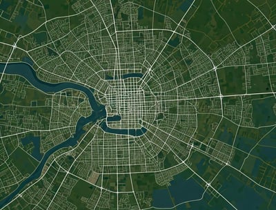
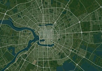
Image Mosaic / Base Map
An on-demand regional coverage product made through assembling many smaller color-unified images, can be produced according to the coverage and resolution as required by the customer. An ideal georeferenced imagery data for visualization, mapping, and planning purposes.
For examples of our base map examples, check out our case studies in our Publications page


GEOSPATIAL ACCURACY
LARGE SCALE MAPPING
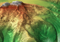
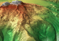
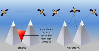
Digital elevation model(DEM)/Digital surface model (DSM)
We offers the most comprehensive range of ELEVATION MODELS providing highly accurate height information everywhere in all the world, whatever the relief and weather conditions. Our DEMs are generated from stereo satellite imagery, ensuring the highest level of detail and accuracy.
Available in both DSM (Digital Surface Model) and DTM (Digital Terrain Model)
Additional complimentary products:
Contour lines
Satellite imagery as background
Feature extraction of main features
3D modeling
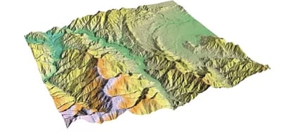


DEM
DSM
Vector Datasets
WE provide geographic objects that contain location and attribute information in geographic information systems (GIS) that represents spatial data using geometric shapes or vectors, such as points, lines, and polygons.
Point Data: Data that specifies a single location, such as important points, electric poles, and valves belonging to the water network, etc.
Line Data: Data that connects natural or artificial structures, such as roads, rivers, railways, telecommunications lines, and ship routes, etc.
Polygon Data: Data that represents closed areas such as provinces, districts, neighborhoods, regions, and countries, etc.


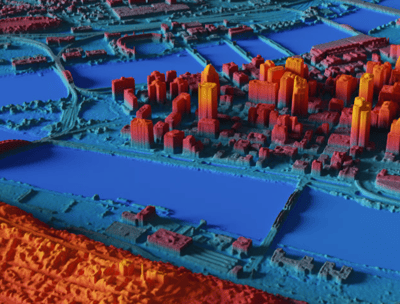
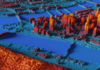
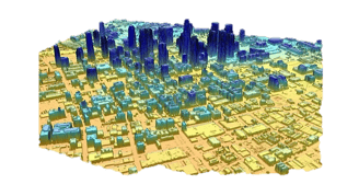
3D Model
Not all data is created equal. Digital Elevation Models (DEM) and advanced 3D visualizations answer crucial questions, provide unique insights and give decision makers the data they require for success. Through partnerships with world leading geospatial services companies, we offer the world’s highest quality optical satellite-based 3D products and solutions.
RAPID PRODUCTION
GLOBAL COVRAGE
GEOSPATIAL ACCURACY


Expertise
Delivering exceptional results in satellite imagery marketing.
Contact Us
Looking for more information?
+20 10 979 555 6
© Smart Tech for smart solutions 2025. All rights reserved.